THE GIS
Having the data geoscientifically attributed and coherently structured in a digital spatial database within a GIS allows powerful and flexible retrievals across political boundaries, both for cross-border planning and decision-making, and for scientific and teaching purposes (Figure 1). A standardized dictionary defines the attributes and terms used to describe the rock units. This is based on the Streckeisen classifications of magmatic rocks (STRECKEISEN 1976, 1978) and the IUGS Stratigraphic Time scale (REMANE et al. 2000, 2004).
THE PRINTED MAP – A CARTOGRAPHIC IMAGE
«The word «map» traditionally implies a paper document,
on which the graphical representation is in a non-digital form.»
(BONHAM-CARTER, 1994)
After Bonham-Carter (see above) a printed map may be called a «cartographic image», because a map is an image from a digital source, but is represented in a traditional, cartographic way and has the characteristics of conventional products of cartography.
The IGME 5000 GIS, therefore, had to be constructed to allow output in the form of such a traditional paper map. Thus, typical cartographical issues such as paper formats and map layout, legend, marginalia and of course a thoughtful choice of the colour set, needed to be considered.
When the IGME 5000 project was initiated in 1994 web-enabled GIS was no more than a concept. Today the concept has become a reality. Internet GIS is the perfect delivery mechanism for the IGME; it allows international access to a map and underlying data which is «international». It could, if desired in the future, remove the significant cost of printing and distributing paper maps and CD ROMs. Lastly, it is dynamic and flexible and can allow users to access more than just the restricted features which appear on the printed map face.
Meanwhile an interim web site for the IGME 5000 project (www.bgr.de/karten/IGME5000/IGME5000.html) was developed, where the colour scheme, the Guidelines, the Guide for the preparation of the data input, the data input mask, general information and news on the project can be obtained and downloaded. A password-protected «Members Only Special Site» provided project participants with the topographic base map.

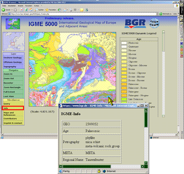
Figure 1 – Example of the IGME 5000 web mapping application. The database contents of each geologicalunit can be shown by first clicking the “info” button and then clicking at one geological polygon.
THE INTERNET MAP
In the course of 2006 an IGME 5000 web mapping application is being developed. A Beta-version has just been demonstrated successfully at the CGMW General Assembly in Paris. Users will be able to see and query the IGME 5000 map and associated data. They may tailor a map according to their own requirements, selecting areas on the map and geological units according to e.g. the age and/or lithology of the rocks. Each unit when clicked on will show a pop-up window listing its attributes in the databases which embrace lithology, age, genetic and tectonic elements, regional names and metamorphic features. A main graphic window will display map/spatial data; a dynamic legend adopted to the displayed map data will be provided; a range of buttons will provide practical functionality, such as zoom, pan, select, query and print. The application is being developed based on the UMN mapserver which has the advantage that of no additional software needs to be installed for viewing the data.
This Web GIS application will be the future central feature of the IGME 5000 internet site. An initial key map will allow the user to define the area of interest and select the chosen geological theme (e.g. Jurassic sedimentary rocks of onshore Europe, or ophiolite complexes of the Dinarides) through a Windows-operated menu.
CONCLUSIONS
The map and GIS is the culmination of twelve years of work of one BGR geologist, a small team of cartographers, a database expert and the cooperation of scientists from 48 countries and more than 20 universities and geoscientific institutions across Europe. The map (ASCH, 2005) has just been completed and printed and was presented for the first time at the General Assembly of the Commission of the Geological Map of the World in February 2006 (UNESCO, Paris). It sets the geology of the whole of Europe in coherent context, and the web mapping application will make the information collected over so many years available to everyone. So the IGME 5000 may become a key information resource to aid understanding of the complex and unique geological history of the continent.
REFERENCES
- ASCH, K. (2003): The 1 : 5 Million International Geological Map of Europe and Adjacent Areas: Development and Implementation of a GIS-enabled Concept; Geologisches Jahrbuch; SA 3, BGR, Hannover (ed.); Schweitzerbart (Stuttgart), 190 p., 45 fig., 46 tab.
- ASCH, K. (2005): The 1 : 5 Million International Geological Map of Europe and Adjacent Areas: Map, BGR (Hannover), 1 map.
- BONHAM-CARTER, G. F. (1994): Geographic Information Systems for Geoscientists, Modelling with GIS.- Computer Methods in the Geosciences; Vol. 13, 398 p.; Kidlington (Pergamon).
- REMANE, J., FAURE-MURET, A., ODIN, G. S. et al. (2000/2004): International Stratigraphic Chart. UNESCO & IUGS.
- STRECKEISEN, A. L. (1976): To each plutonic rock its proper name. Earth-Science Reviews, 12, 1-34.
- STRECKEISEN, A. L. (1978): Classification and nomenclature of volcanic rocks, lamprophyres, carbonitites and melilitic rocks. IUGS Subcommission on the Systematics of Igneous Rocks. Neues Jahrbuch für Mineralogie-Abhandlungen, 141, 1-14.
RELEVANT WEB SITES
- Million International Geological Map of Europe and Adjacent Areas (IGME 5000): http://www.bgr.de/karten/IGME5000.
- Bundesanstalt für Geowissenschaften und Rohstoffe (BGR):
http://www.bgr.bund.de. - Commission for the Geological Map of the World (CGMW): http://ccgm.free.fr/.
- The map is available from http://www.karten-schrieb.de. Commission for the Management and Application of Geoscience Information (CGI): http://www.cgi-iugs.org.
- International Union of Geological Sciences (IUGS): http://www.iugs.org/home.htm.