Throughout the long history of the mining development of the Cardona’s diapir, there have been several episodes of groundwater inflow due to the interception of karst conduits. Over the years, the karst development resulted in 1997 the hydraulic connection between the alluvial aquifer and the mine, causing environmental and operation problems in the mine. To minimize them, several activities were carried out: the diversion of the Cardener River in 2000; building impermeable subsurface barriers in order to restrict the movement of groundwater flow into the mine; groundwater dewatering wells, etc.
Since 2011, the ICGC (ICGC-GEOCAT, 2012) has launched a project to improve the management of groundwater. This project focus on these following issues:: better understanding and control of groundwater; conducting proper monitoring; and improving the geological understanding. In the current phase, a 3D geological model of the tertiary detrital units is being developed to provide new tools for analysis and resolution.
GEOLOGICAL SITUATION
The study area is located in the Meandre de La Coromina, in the NE of the Vall Salina, Cardona, where the valley merges with the old bed of Cardener River.
The core of the Cardona’s diapir outcrops in the Vall Salina. This salt anticline is a part of a SW-NE folding system. In the Meandre de La Coromina area, it has a plunge towards the NE. The closing periclinal of the fold and the NE boundary of the diapir make it visible.
This predominant structure of the basement is faulted, including perpendicular faults on the direction of folding. These ones do not just increase the NE termination of the diapir, but they would also be decisive for the karst development (Font, 1985). There are also E-W faults, detected basically on drilling works.
The materials involved belong to the Upper Eocene – Oligocene: the diapir’s core is made up of the evaporitic deposits of Fm.Cardona and the overlying units are constituted by sandstones and marls of Fm.Súria and Fm.Solsona. The tertiary basement is partially covered by quaternary deposits which are alluvial-colluvial, in the margins of the valley, and fluvial in the Cardener’s area.
METHODOLOGY
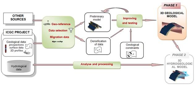
With the purpose to generate a 3D geological model of the tertiary detrital units, a workflow has been taken into account following these steps:

Figure 1. Workflow to construct the 3D geology model.
- Compilation and geo-referencing of primary data.
The monitoring project has allowed us to collect a set of important information. In addition to the hydrogeological data (transmissivity data, piezometric measures…), a set of geological information has been obtained such as multiple drilling works made for different purposes (piezometers, dewatering wells, etc.). In particular, 8 inclined boreholes, drilled between 1933 and 1954, in order to delimit the NE boundary of the diapir, under the alluvial materials. Moreover, as result of multiple explorations, surface data have been gathered, including dip data and surface cartography. Finally, some 2D cross-sections have been generated as basic tools for the visualization of the geological structure. - Analysis of primary data according to their utility for the future 3D model.
- Migration of the data, from 2D to 3D. Previously, the data had been processed from CAD (DWG, DGN) and GIS (shape files) environments, because of their high interoperability and easy handling. To integrate the new software, there has been an adaptation of formats and content information.
- Generating the 3D model using specialized software: GOCAD by Paradigm and MOVE by Midland Valley. Based on the structural analysis of the data, a preliminary model has been generated using the dip-domains method (Gronshong, 1999).
- Improving the model with the densification of the data and the addition of geological constraints. Moreover, in the process of modelling, various interpolations were tested in successive iterations. The outcome is a deterministic structural model with the creation of several surfaces (lithological contacts and faults) which show the structure of the subsurface.
- Transformation of the generated 3D surfaces into meshes, contour maps, etc. for 3D visualizations or being used in flow models.
REFERENCES
- FONT, J. (2005) – Comportament de l’aigua subterrània a la VallSalada de Cardona (Manresa).Doctoral Thesis.Universitat Politècnica de Catalunya.
- GROSHONG R.H. (1999) – 3D structural geology: a practical guide to surface and subsurface map interpretation. Springer, Berlin, 324 pp.
- ICGC-Geocat (2012) – Estudi hidrogeològic dels bombejos relacionats amb l’explotació minera de Salinera de Cardona, SL. Fase 1.Anàlisis, tractament i síntesi de les dades disponibles, elaboració de propostes i recomanacions de treballs futurs. Barcelona, 159 pp.
- ICGC-Geocat (2013) – Estudi hidrogeològic d’anàlisi dels bombejos relacionats amb l’explotació minera de Salinera de Cardona, SL Fase 2A: Seguiment de la campanya de sondeigs d’investigació hidrogeològica als sectors Ai B, seguiment de l’assaig d’interrupció del cabal d’abocament a la llera, actualització general de les dadesi re-interpretació de resultats. Barcelona, 339 pp.


