The Geological Survey of Canada (GSC) is Canada’s oldest scientific agency and one of its first government organizations. It was founded in 1842 and first led by geologist William Edmond Logan to help develop a viable Canadian mineral industry by establishing the general geological base on which industry could plan detailed exploration and investigations. The importance of the mining industry to Canada’s economy has been recognized since the beginning of the GSC.
Geophysical mapping became a key component of field planning at the GSC in the mid-fifties with the introduction of aeromagnetic mapping in advance of on-the-ground field campaigns. Aeromagnetic maps were produced to guide the exploration activities of mining and petroleum companies. Over the years, newly developed geophysical methods that became available were included as key components of projects requiring characterization of the subsurface. Geophysical applications at the GSC range from the characterization of shallow aquifers, to the definition of areas at risk for natural geological and related geohazards. Geophysics is also used to evaluate the potential of selected sedimentary areas for the underground sequestration of CO2, and to provide base information for mineral and petroleum exploration. The various geophysical techniques in use today include gravity, magnetic, seismic, electromagnetic, and borehole geophysical methods. All research, information and data acquired by the GSC are public, free of charge, and are available for download using online tools (http://gdr.agg.nrcan.gc.ca and http://geoscan.nrcan.gc.ca).
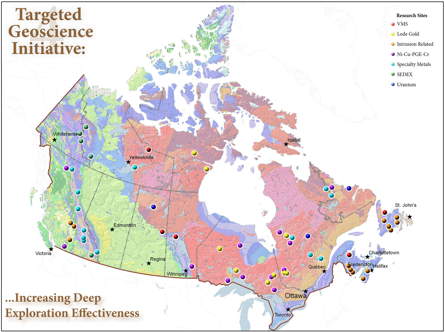
At the time of the GSC’s foundation, coal was in high demand but societal needs quickly evolved to include copper, zinc, and precious metals. The past 30 years have seen a marked decline in proven and probable Canadian mineral reserves in all the major base metals. Deeper exploration for new resources is now required because of the increasing rarity of surface discoveries. The GSC addresses this challenge through its Targeted Geoscience Initiative 4 (TGI-4) which provides industry with the next generation of geoscience knowledge and innovative techniques (Figure 1). The TGI-4 program is designed to provide the mineral exploration industry with advanced geoscience knowledge in support of reducing exploration risk and enable more effective targeting of buried mineral deposits.

Figure 1. Map with a location of the different Targeted Geoscience Initiatives (TGI-4).
As part of TGI-4, the GSC acquired a 16 km2 3D seismic data set over the Cu-Zn-Pb-Au-Ag Lalor volcanogenic massive sulphide deposit near Snow Lake, Manitoba, Canada, to assess the effectiveness of the seismic reflection method for deep mineral exploration. The Lalor deposit was chosen as a test site as it provided an intact, well-characterized 29 Mt deep ore deposit with a rich catalogue of geological and geophysical data, as well as extensive drill-core, and drill hole geophysical and geological logs that would contribute to validate results obtained from the 3D seismic data. The Lalor deposit comprises six zinc-rich zones and six gold-rich zones located at depth ranging between 570 m and 1160 m. The gold zones are the smallest and deepest and locally cut through the shallower and larger zinc zones.
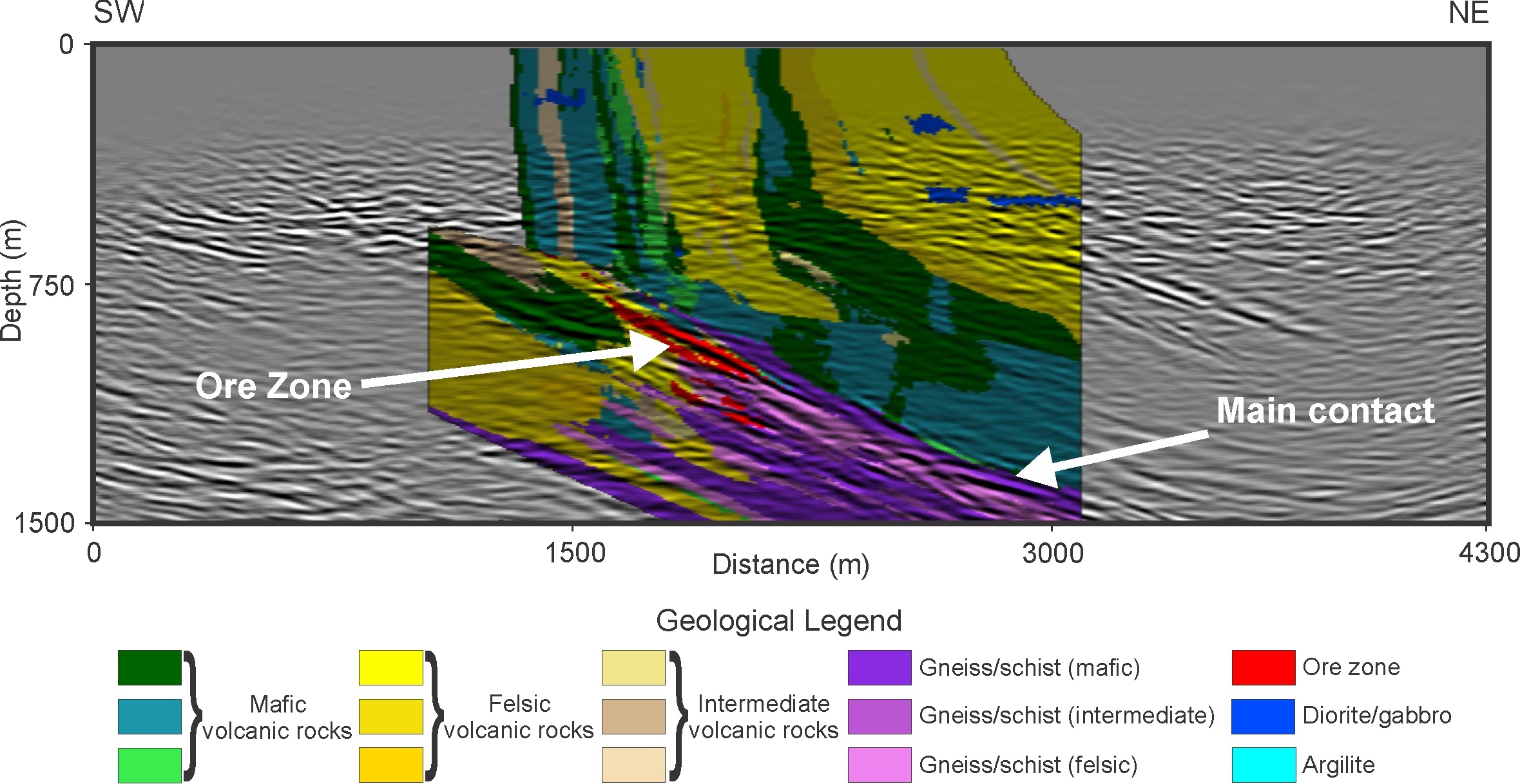
At Lalor, dynamite was used to generate seismic waves at 910 locations distributed as evenly as possible over the survey area. The seismic waves produced at those locations propagated in the subsurface and were reflected from deep structures. The reflected waves were recorded at 2,685 receiver stations also placed at surface and were combined to produce a 3D image of the reflecting structures in the subsurface, some of which corresponded to the ore deposit. Figure 1 shows one vertical section from the 3D seismic data with a strong amplitude reflection associated with one of the zinc-rich zones. The different rock types obtained from a 3D geological model are also overlaid in colour on top of the seismic section. One of the main contacts associated with most of the mineralization in the Snow Lake mining camp is also detected on the seismic data (Figure 2), demonstrating that seismic reflection methods can also be used to track the key horizons in the area.
Results over the Lalor deposit confirm that the seismic reflection method provides an effective means to detect and image deep-seated ore bodies and to provide other useful subsurface information in mining environments. However, the need to “see” at depth is non-exclusive to mining environment. A wide range of applications require high quality images that cannot be easily or cost effectively obtained with drill holes. To this end, seismic methods as well as other geophysical methods will remain important techniques as the need to characterise the subsurface for a wide range of depths and scales will only increase in the future.

Figure 2. SW-NE vertical section from the TGI-4 Lalor 3D seismic volume. The seismic section is shown in grayscale. Geological information (where available) is painted on top of the section. Strong reflections are associated with one of the zinc-rich zones of the Lalor deposit (arrow pointing to the ore zone). The section also shows other reflections, some corresponding to the main contact hosting most of the mineralization in the Snow Lake mining camp (arrow pointing to main contact).


